The weather forecasters by no means always get is right, and as a boat angler you need to be ready with a good understanding of weather systems and terminology… with Jim O’Donnell
IF you think that weather forecasting is an exact science in these high tech days, think again.
Watch your local forecast’s 3-5 day out look and notice how it changes each day. When each day finally you often get something totally different to what was forecast, which as you can imagine is of no help to the boat angler or charter skipper.
In its simplest form UK weather comes in two different styles – low pressure and high pressure.
Low pressure usually heralds the arrival of rain and high winds and its relative high pressure usually brings with it fair sunny weather and usually lighter winds.
Both can have their variations but at its simplest that is the weather. All weather systems, whether high or low pressure, are born because of heat from the sun.
The sun heats air in certain areas of the world causing it to rise. This hot, rising air is then replaced by colder air, which moves in from other parts of the word.
The easiest way to describe this is to say that both these hot and cold winds spiral around each other and create our weather systems, as we know them. All UK weather is born out in the middle of the Atlantic in an area known as the polar front.
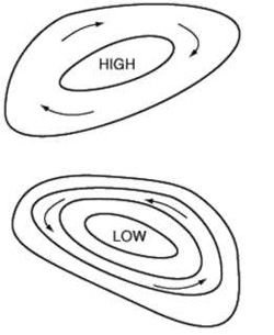 |
| Isobars are used to determine wind speed and direction. |
Isobars
The bread and butter of all weather systems and forecasting are isobars. These are lines drawn on the charts to join places of equal barometric pressure {for those of you that understand ordinance survey maps, it’s like contours that join equal heights on hills etc}. These isobars are the circular lines that dominate all weather charts. Isobars are very important as they are used to determine wind speeds and wind direction.
Wind direction
Winds travel around pressure systems following the isobars parallel to them. Around low pressure systems, winds travel in an anticlockwise direction and around high pressure systems, they travel in a clockwise direction.
Hence the forecasters terms cyclonic {clockwise} and anticyclonic {anticlockwise}.
Wind speed
To determine the wind speed you need to use something called a geostrophic scale, these are located somewhere on most weather charts. A geostropic scale is a small graph that converts distance between isobars into wind speed relative to certain areas. First, find the isobars closest to where you wish to fish. Use a compass or ruler to measure this distance between the two nearest isobars to where you are and then transfer this measurement to the graph according to your position in degrees. The whole of the UK lies between 50 and 60 degrees north, so if you are somewhere around these readings you will get a pretty accurate result.
Measure distance from a to b and transfer to Geostrphic graph below.
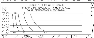
Degrees north is on the vertical scale and wind speed can be measured of against the horizontal scale.
Hopefully when you have transferred your measurement you should end up with a wind speed in knots.
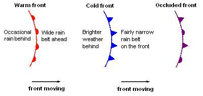
Fronts
Fronts are horrible things on low pressure systems that usually bring rain, a change of wind direction and an increase in wind. There are three main fronts to watch for: warm, cold and occluded, and each has its own characteristics.
Warm Front
As the front approaches the wind increases and changes direction slightly. Cloud thickens and rain becomes heavy with poor visibility. As the front passes, the wind returns to its original direction and eases, rain becomes light and drizzly and visibility gets slightly better.
Cold Front
As the front approaches the wind changes direction again and increases. Cloud thickens, visability decreases and rain can be heavy. As the front passes rain stops, visibility increases but winds can remain strong or squally for some time.
Occluded Front
Occluded fronts display similar characteristics as cold or warm fronts, but the front is actually less active and spent because the warm and cold fronts have joined together. Occluded fronts will generally have weaker properties than the other types of front above.

Useful websites for forecasting your own weather
The following sites can provide excellent information for predicting weather from comfort of your own home or office.
www.metoffice.gov.uk : This is the United Kingdom’s Met Office website home page. Loads of information can be found here but I tend to use, www.metoffice.gov.uk/datafiles/inshore.html for the country’s inshore waters forecast and www.metoffice.gov.uk/datafiles/offshore.html for the country’s shipping forecast when planning boat fishing trips.
http://weather.noaa.gov : This is the United States version of the Met office, yet again there is tons of weather information to be found especially the weather charts listed 22 till 29 at http://weather.noaa.gov/fax/otherfax.shtml . They are laid out at 12 hour intervals and tend to be very reliable.
Current conditions at sea can be found out from using data buoys, which are out at sea observing all the time. This information can be found at http://www.ndbc.noaa.gov/index.shtml . Upon entrance to the site there is a click on map so you just click on the area you require information for and up it comes.
When beach fishing I can check the surf actually on the beach and predicted surf heights by checking the swell animation charts at http://www.a1surf.com/weathercheck.html .
Conclusion
I hope the above information will help you start to learn to predict your own weather as I have. When you combine this home forecasting with national television forecasts and then use the law of averages method, you will have a good idea about what is about to happen. In fact with a little practice and a bit more in depth study you can become quite good at it and the end result means you have less wasted journeys to fish aboard charter trips that end up cancelled and you don’t end up standing on the beach with 10ft breakers, force 10 winds and horizontal rain.
Oh yeah, and by the way if all else fails buy yourself a barometer and remember the following saying.
“When the wind backs and the weather glass falls, then be on your guard against gales and squalls.” All scientific stuff you see!
Jim O’Donnell, ‘Tiberon’, Plymouth, Tel 07855 040015; Email: skipperjim@blueyonder.co.uk
![]()